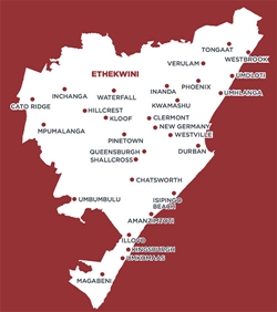
eThekwini Metropolitan Municipality
is one of eight Category A municipalities in South Africa, and one of 11
districts in KwaZulu-Natal. eThekwini
Municipality is bordered in the north by the Ilembe District Municipality, to
the east by the Indian Ocean, to the south by the Ugu and the Umgungundlovu District
Municipalities. It stretches beyond Umkomaas in the south to
the Tugela River in the north, and to Cato Ridge in the west. The outer areas are less populated and
include a mix of growing industrial activities (at Umkomaas, Cato Ridge, Ilembe
and the Dube Trade Port), agricultural areas (including sugar cane), and
natural areas.
Air pollution in eThekwini Municipality and its potential impacts on human health has been highlighted for a number of years, leading to the implementation of the Multi-Point Plan (MPP) in 2002, focusing on the South Industrial Basin. The associated Health Study confirmed high levels of exposure to air pollution in the residential areas surrounding the SIB. The MPP resulted in a dramatic decrease in the emission of sulphur dioxide (SO2) by industries in the SIB and a concomitant decrease in ambient SO2 concentrations. With the focus on the SIB little is known however about air pollution elsewhere in the eThekwini Municipality.
The Pollution Control and Risk Management (PCRM)
section of eThekwini Municipality’s Health Unit developed and implemented an
Air Quality Management Plan (AQMP) in 2007. eThekwini Health Unit’s is
embarking on a project to assess, evaluate, review, and update the AQMP in
accordance with the requirements of the National Environmental Management: Air
Quality Act (NEM:AQA) (Act No. 39 of 2004). uMoya-NILU Consulting (Pty) Ltd was appointed to
assist eThekwini Municipality and lead the revision of the AQMP. The AQMP review is an 18 month project and is
planned to conclude in November 2015.